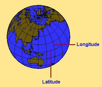
Longitude is the angular distance east or west, between
the meridian of a particular place and that of Greenwich, England,
expressed in degrees or time. Each Longitudinal Line is marked with
a measurement of degree east or west.
Latitude is the angular distance north or south from the
equator, measured in degrees on the meridian of a point. Each
latitudinal line is marked with a measurement of degree north or south.
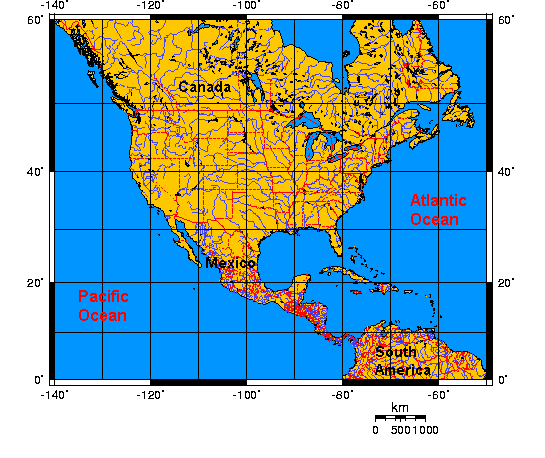
Look at the map below.
The map below is a Mercator Map. Use the map below
to answer the following questions.
What US state is located south of 40 degrees latitude
and -120 degrees longitude?
What continent is located south of 10 degrees
latitude?
What country does the 50 degrees latitudinal line
cross?
If you stand at 20 degrees latitude and -100 degrees
longitude, you will be in
What ocean does the -120 degrees longitude line
cross?
Ocean.
What ocean does the -60 degrees longitude line
cross?
Ocean.
The state of Texas lies at
degrees latitude and
degrees longitude.
Most of Florida is below the
degree latitude line.
The Great Lakes can be found below
degrees latitude and above
degrees latitude.
Elementary & Middle School Lessons & Self-Correcting Tests for Children in all Subject Areas. If you have found an error or would like to make comments on this lesson,
please email us at:
MySchoolhouse.online@gmail.com
Copyright 1999-2024 by Educational Designers, LLC. All rights reserved. Lessons & Tests in Math, Reading, Spelling, Science, Language, and Social Studies.
"This site uses cookies from Google to deliver its services and analyze
traffic. Your IP address and user-agent are shared with Google along with
performance and security metrics to ensure quality of service, generate
usage statistics, and to detect and address abuse."